Assessing impacts to critical infrastructure from multi-hazard events

Hazards can sometimes occur simultaneously or in succession. One hazard can also set off another: earthquakes can cause landslides, while heavy rainfall can generate both floods and landslides.
A multi-hazard framework
Using earthquakes, landslides, and flooding in the Central Macedonia region of Greece as a case study, MIRACA researchers from Aristotle University of Thessaloniki developed a framework to calculate multi-hazard risk to critical infrastructure, focusing on essential services such as schools and hospitals.
The study area of Central Macedonia

Geographic exposure to earthquake and flood hazards
The first step is understanding where different hazards affect the same places. In Central Macedonia, earthquake and flood hazard maps reveal exposed areas. This overlap of exposure means that the same buildings and infrastructure need to withstand more than one type of extreme event.
Areas of Central Macedonia exposed to earthquakes and floods

When hazards interact, impacts can increase
Exposure to multiple hazards becomes particularly important when those hazards occur together or interact. A building already damaged by an earthquake, for example, may be more vulnerable to flooding.
By analysing these relationships, researchers can estimate how much additional damage may occur when infrastructure faces multiple hazards at the same time rather than just one at a time.
The maps below show the extent of the damage expected to school buildings when earthquakes and floods of different severities happen together.
Lost value to school buildings from multi-hazard exposure

When considering the multiple hazards together, earthquakes account for most of the overall risk. A stronger earthquake combined with a smaller flood reveals higher loses than a smaller earthquake combined with a larger flood, indeed in the former scenario many school buildings will suffer the highest loss ratios considered, 30-40%. Earthquakes are expected to cause significant damage to school buildings across the study area, while flood impacts are largely confined to schools near rivers.
Putting a cost to interacting hazards: How much do we underestimate losses if we ignore landslides?
The difference between considering hazards alone and considering multiple hazards can also be seen when economic losses are calculated. Analysing earthquakes and landslides together produces higher estimates of damage to schools than considering earthquakes alone. The greater the likelihood that an earthquake triggers a landslide, the greater the estimated losses, as depicted in the chart below.
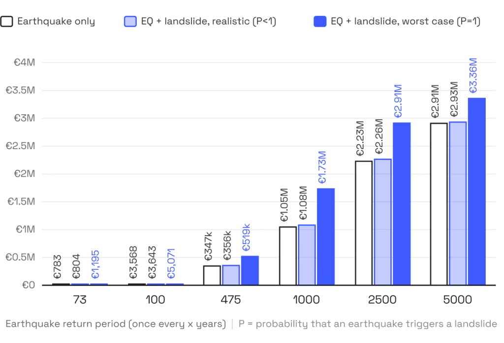
In the worst case scenario, where every earthquake is assumed to trigger a landslide (PL=1.0), the increase is substantial, showing why interactions between hazards matter for risk planning.
In conclusion, the benefits of multi hazard assessment
Looking at hazards together reveals risks that can be missed when they are assessed separately. By showing where hazards overlap, how they interact, and how these interactions change expected losses, multi-hazard assessment gives authorities a more complete picture of the risks facing communities and critical infrastructure.
This broader perspective can help authorities move beyond single-hazard planning and make better-informed decisions about where adaptation and resilience measures can make the greatest difference.
Designed to be open and extended to any area in Europe, the framework uses freely available European earthquake and flood datasets and integrates climate change scenarios to better anticipate future risks.
Visit the MIRACA book to explore the methodology, access the code and datasets, and start applying multi-hazard risk assessment in your own community.
References
- Fotopoulou, S.; Karatzetzou, A.; Tsoumani, P.; Karafagka, S.; Pitilakis, D. Multi-Hazard Risk Assessment of Critical Infrastructure Using Pan-European Open Datasets: A Unified Framework Applied to Schools Under Flood, Earthquake, and Landslide Hazards. Sustainability 2026, 18, 6871. https://doi.org/10.3390/su18136871